What are raster images?⚓︎
Raster images⚓︎
A raster image is a 2D array or matrix that stores a pixel value for each pixel. If the image is colored, then each pixel is usually stored as a 3D vector of numbers that represent values for red, green, and blue. These rgb values are commonly referred to as subpixels. If the image is not colored, then each pixel stores a single value which controls the brightness of that pixel and the image is called grayscale.
Where are the pixels in 2D space?⚓︎
This is an important question, but it's really just a matter of convention. For instance, some references count pixel positions \((i, j)\) starting from the upper left corner similar to a matrix:
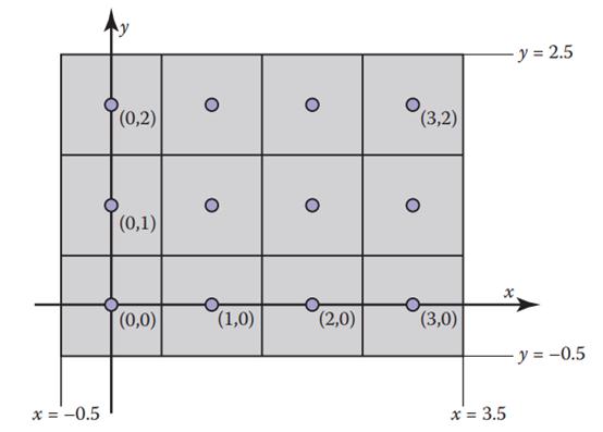
Reasons for this are historical and have to do with the way that rows in analog television transmissions started from the top left. In any case, we'll set our raster image inside a cartesian plane such that when we refer to pixel \((i, j)\), we are saying that this pixel lives at column \(i\) and row \(j\) starting from the bottom left corner:

In the image shown above, we can say that there are \((n_x \times n_y) = (4 \times 3)\) pixels.